
United Kingdom Light Detection and Ranging Drone Market - United Kingdom Size & Outlook 2025-2034
United Kingdom Light Detection and Ranging (Lidar) Drone Market is segmented by Application (Surveying & Mapping, Agriculture Monitoring, Infrastructure Inspection, Environmental Monitoring, Security & Surveillance), Type (Fixed-wing Lidar Drones, Rotary-wing Lidar Drones, Hybrid Lidar Drones, Tethered Lidar Drones), and Geography (England, Scotland, Wales, Northern Ireland)
Pricing
Report Overview
Executive Summary
- •The United Kingdom Light Detection and Ranging (Lidar) Drone market includes unmanned aerial vehicles equipped with Lidar sensors used for precise topographic mapping, environmental monitoring, agriculture, infrastructure inspection, and security. This sector integrates various drone types and software analytics, facilitating real-time data acquisition and enhanced operational insights across multiple industries.
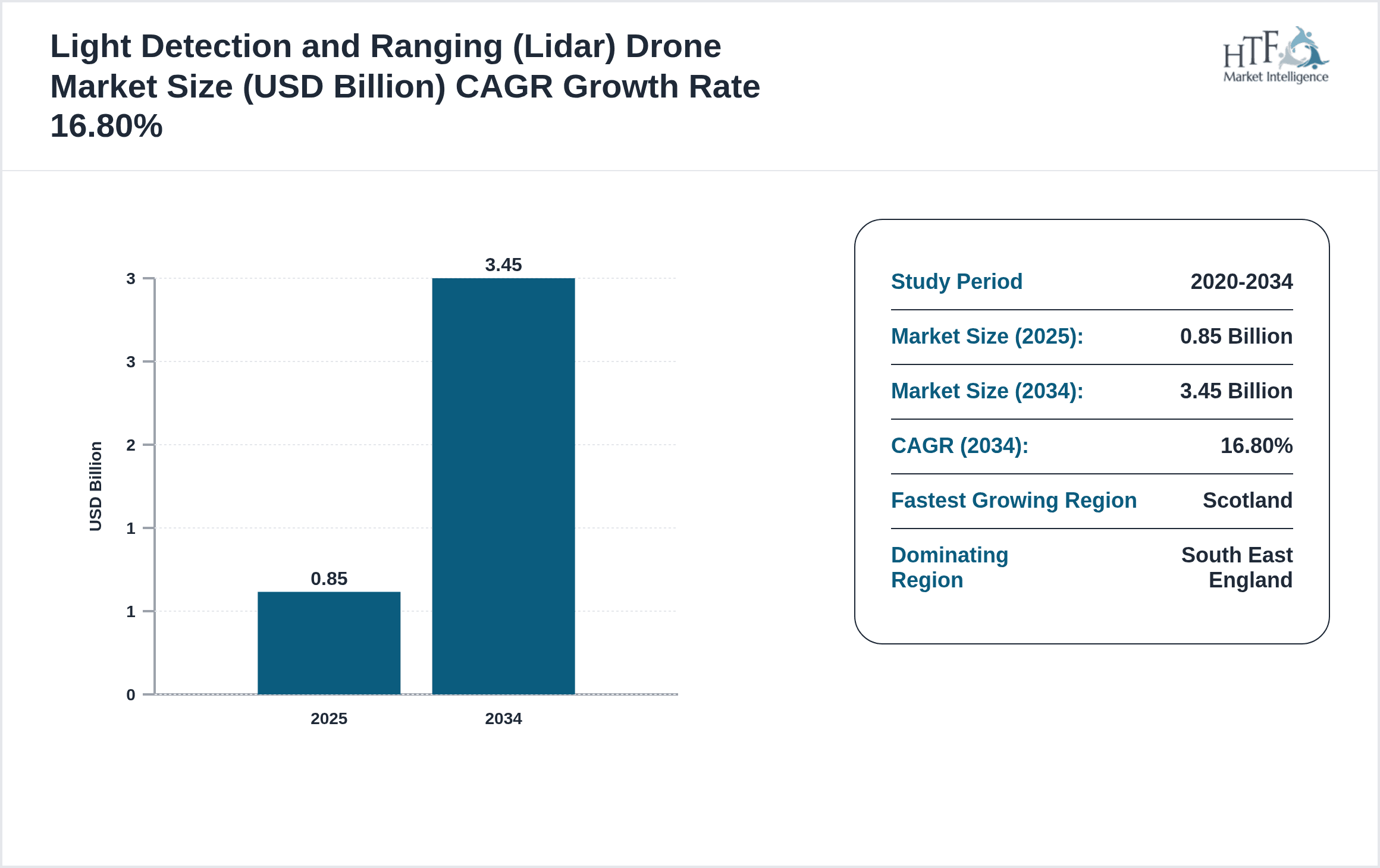
- •Key market highlights include strong adoption of rotary-wing Lidar drones dominating at 32% market share by 2025, with hybrid Lidar drones identified as the fastest growing segment, projected at a CAGR of 19.5% through 2034. The market size is forecasted to grow from USD 0.85 Billion in 2025 to USD 3.45 Billion by 2034, reflecting a CAGR of 16.8%.
- •The market’s value proposition lies in enabling highly accurate spatial data collection and analysis, which supports efficient decision-making in construction, agriculture, environmental conservation, and public safety. The evolving regulatory framework and technological advancements further position the UK as a growing hub for Lidar drone innovation and deployment.
Competitive Landscape
The United Kingdom Lidar Drone market exhibits robust competition characterized by rapid innovation, strategic partnerships, and diversification of product offerings. Companies are investing heavily in R&D to enhance sensor accuracy, flight endurance, and data processing capabilities. Competitive positioning is influenced by technological differentiation, after-sales services, and regulatory compliance. The market rivalry encourages continuous product improvements and adoption of AI-enabled data analytics to gain a competitive edge. Barriers to entry include high capital requirements and complex certification processes, fostering a competitive environment dominated by technologically advanced firms with established distribution networks.
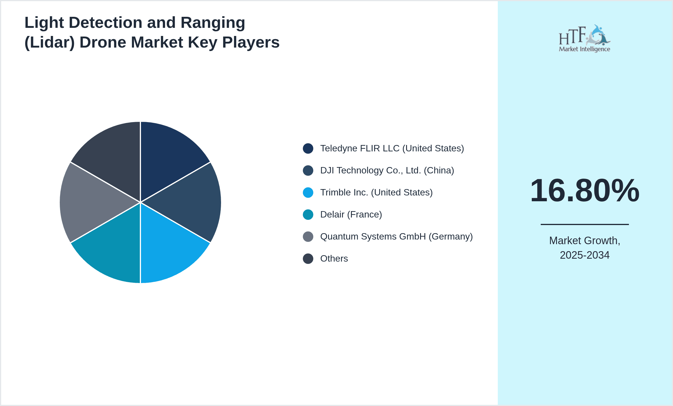
Leading Companies in United Kingdom Light Detection and Ranging (Lidar) Drone Market
- •Teledyne FLIR LLC (United States)
- •DJI Technology Co., Ltd. (China)
- •Trimble Inc. (United States)
- •Delair (France)
- •Quantum Systems GmbH (Germany)
- •Parrot Drones SAS (France)
- •senseFly (Switzerland)
- •Yellowscan (France)
- •RIEGL Laser Measurement Systems GmbH (Austria)
- •Velodyne Lidar, Inc. (United States)
- •Blue Ocean Robotics (Denmark)
- •MicaSense (United States)
- •Geoscan (Russia)
- •Hexagon AB (Sweden)
- •Flyability SA (Switzerland)
- •AeroVironment, Inc. (United States)
- •Quantum-Systems GmbH (Germany)
- •DroneDeploy (United States)
- •Delair-Tech SAS (France)
- •Autel Robotics (United States)
- •Lockheed Martin Corporation (United States)
- •Boeing Company (United States)
- •Parrot SA (France)
- •PrecisionHawk (United States)
- •Insitu Inc. (United States)

Market Breakdown
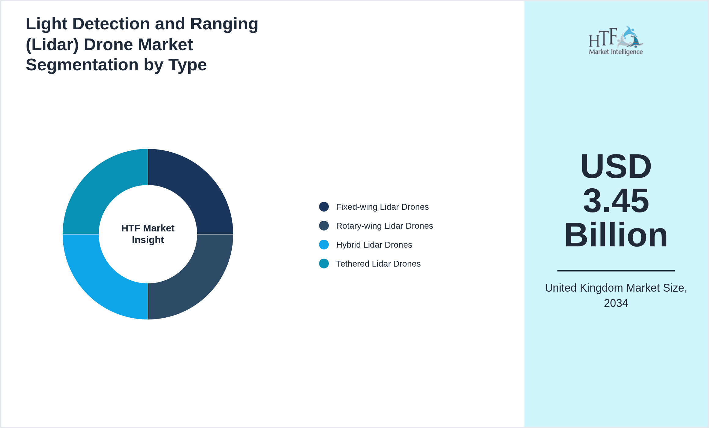
- •By Type
- ◦Fixed-wing Lidar Drones
- ◦Rotary-wing Lidar Drones
- ◦Hybrid Lidar Drones
- ◦Tethered Lidar Drones
- •By Application
- ◦Surveying & Mapping
- ◦Agriculture Monitoring
- ◦Infrastructure Inspection
- ◦Environmental Monitoring
- ◦Security & Surveillance
- •By End User
- ◦Construction Companies
- ◦Agriculture Enterprises
- ◦Government Agencies
- ◦Environmental Organizations
- ◦Defense & Security
- •By Distribution Channel
- ◦Direct Sales
- ◦Third-party Distributors
- ◦Online Retail
- ◦System Integrators
Growth Drivers
- •Increasing demand for precise geospatial data in construction and urban planning drives adoption of Lidar drones, enabling efficient project monitoring and reducing manual survey costs across the UK market.
- •Advancements in sensor technologies and integration with AI-based analytics enhance drone capabilities, attracting investment in hybrid Lidar drones with superior flight times and data accuracy.
- •Government initiatives promoting smart agriculture and environmental monitoring stimulate market growth by encouraging deployment of Lidar drones for crop health assessment and ecological surveys.
- •Rising safety regulations in infrastructure inspections mandate non-invasive monitoring techniques, boosting demand for rotary-wing Lidar drones capable of accessing difficult locations.
- •Growing public and private sector investments in drone-enabled security and surveillance systems drive technological adoption, expanding end-user applications within the UK.
Market Trends
- •Integration of Lidar drones with cloud-based data processing platforms facilitates real-time analytics and decision-making, enhancing operational efficiency in surveying and agriculture.
- •Emergence of hybrid drones combining fixed-wing endurance with rotary-wing maneuverability is reshaping market preferences by offering versatile solutions for diverse applications.
- •Collaborations between drone manufacturers and software firms are accelerating development of specialized applications, including AI-driven anomaly detection in infrastructure maintenance.
- •Sustainability initiatives in the UK promote use of Lidar drones for environmental impact assessments, supporting compliance with evolving ecological regulations.
- •Expansion of commercial drone services through third-party providers is increasing accessibility of Lidar technology for small and medium-sized enterprises.
Market Restraints
- •High initial investment costs for advanced Lidar drones and associated software limit adoption, particularly among smaller enterprises and startups within the UK.
- •Stringent regulatory requirements for drone operations, including flight permissions and data privacy laws, pose operational challenges and slow market penetration.
- •Technical limitations such as limited battery life and payload capacity restrict flight duration and sensor integration, impacting large-scale deployment feasibility.
- •Concerns over data security and intellectual property rights inhibit full-scale adoption of cloud-based Lidar data analytics platforms.
- •Lack of standardized protocols for Lidar data collection and processing leads to interoperability issues and inconsistent data quality across applications.
Market Opportunities
- •Rising demand for precision agriculture offers significant growth potential for Lidar drones in monitoring crop health, optimizing irrigation, and improving yield prediction accuracy.
- •Expansion of infrastructure inspection services targeting aging bridges, railways, and energy assets presents lucrative opportunities for rotary and hybrid Lidar drone applications.
- •Technological advancements enabling miniaturized, cost-effective Lidar sensors can drive broader adoption across new sectors including insurance and disaster management.
- •Partnerships between drone manufacturers and academic institutions in the UK are fostering innovation and accelerating commercialization of next-generation Lidar drone systems.
- •Development of localized data processing centers aligned with UK data protection laws enhances customer confidence and supports market expansion.
Market Challenges
- •Navigating complex airspace regulations while ensuring safe and compliant drone operations remains a significant challenge for market participants.
- •Skilled workforce shortages in Lidar data analysis and drone piloting hamper scaling of operations and limit service quality.
- •Rapid technological changes require continuous capital expenditure and adaptation efforts, increasing operational risks for companies.
- •Competitive pressure from international firms with lower production costs creates pricing challenges for UK-based manufacturers.
- •Ensuring interoperability between hardware and software systems from diverse vendors complicates integration and user adoption.
Regulatory Framework
- •Between 2020 and 2025, the UK Civil Aviation Authority (CAA) updated drone operational standards mandating comprehensive risk assessments and pilot competency certifications for Lidar drone missions.
- •The Data Protection Act 2018 enforcement requires strict compliance regarding Lidar data collection, storage, and usage, impacting operational protocols for drone service providers.
- •Environmental impact regulations introduced in 2023 require Lidar drone operators to adhere to noise and wildlife disturbance limitations, especially in protected areas.
- •The UK government’s Drone Strategy 2024 promotes integration of drones into national airspace with defined corridors and remote identification systems to enhance safety and accountability.
- •Incentive frameworks supporting drone technology adoption include grants and tax reliefs for R&D in Lidar sensor development and autonomous flight systems.
Industry Insights
- •In April 2024, Delair launched a new hybrid Lidar drone model featuring extended flight endurance and enhanced sensor resolution tailored for complex infrastructure inspections across the UK. This innovation addresses growing demand for versatile drone solutions capable of multi-mission deployment, streamlining data acquisition workflows for engineering firms.
- •In November 2023, Parrot Drones SAS announced strategic collaboration with a UK-based AI analytics startup to develop advanced Lidar data processing algorithms. The partnership aims to deliver real-time anomaly detection and predictive maintenance insights, reinforcing the market’s move towards integrated hardware-software ecosystems.
Mergers & Acquisitions
- •In September 2024, Trimble Inc. completed the acquisition of a UK-based Lidar technology firm specializing in drone sensor miniaturization. This move enhances Trimble’s product portfolio with cutting-edge Lidar sensors optimized for small UAV platforms, strengthening its competitive position in the UK market and expanding capabilities for precision agriculture and surveying applications.
- •In March 2023, Quantum Systems GmbH acquired a UK drone software company focused on autonomous flight control and data integration. The acquisition enables Quantum Systems to offer end-to-end Lidar drone solutions combining advanced hardware with proprietary software, accelerating market penetration in the UK’s infrastructure and environmental sectors.
Recent Industry News
- •15th January 2025, DJI Technology Co., Ltd. announced the launch of its latest rotary-wing Lidar drone equipped with AI-assisted navigation and enhanced obstacle avoidance, designed specifically for UK infrastructure inspection markets. This product targets efficiency improvements and operational safety, providing UK enterprises with advanced data collection capabilities. Source: DJI Official Website
- •5th March 2025, Velodyne Lidar, Inc. expanded its UK operations by opening a regional R&D center focused on developing lightweight Lidar sensors for drone applications. This expansion aims to accelerate innovation cycles and cater to growing local demand for high-precision surveying solutions. Source: Velodyne Press Release
- •22nd May 2025, Parrot Drones SAS partnered with a leading UK agricultural cooperative to pilot Lidar drone technology for crop monitoring, enabling data-driven decisions to improve yields and resource management. The program highlights the rising adoption of drone technology in the UK’s farming sector. Source: Industry Newswire
- •10th July 2025, senseFly launched a cloud-based Lidar data analytics platform tailored for UK environmental agencies, facilitating rapid processing and visualization of terrain and vegetation data collected via drones. This initiative supports regulatory compliance and environmental conservation efforts. Source: senseFly Corporate Announcement
Market Statistics
- •CAGR by 2034: 16.8%
- •Market Size by 2034: USD 3.45 Billion
- •Market Size in 2025: USD 0.85 Billion
- •Dominating Type: Rotary-wing Lidar Drones
- •Next-following Type: Hybrid Lidar Drones
- •Dominating Application: Surveying & Mapping
- •Next-following Application: Agriculture Monitoring
- •Dominating Region: South East England
- •Second-leading Region: Greater London
- •Region with Highest Growth Rate: Scotland
- •Dominating Country: United Kingdom
Market Share Table
- •Market Share (%) - Dominating vs Followed Type: Rotary-wing Lidar Drones (32%) vs Hybrid Lidar Drones (22%)
- •Market Share (%) - Dominating vs Followed Application: Surveying & Mapping (35%) vs Agriculture Monitoring (25%)
- •Growth Rate (%) - Dominating vs Followed Type: Rotary-wing Lidar Drones (15.5%) vs Hybrid Lidar Drones (19.5%)
- •Growth Rate (%) - Dominating vs Followed Application: Surveying & Mapping (16.0%) vs Agriculture Monitoring (18.2%)
Top Companies Profiled in United Kingdom Light Detection and Ranging (Lidar) Drone Market
- •DJI Technology Co., Ltd. (China)
- •Trimble Inc. (United States)
- •Delair (France)
- •Parrot Drones SAS (France)
- •Quantum Systems GmbH (Germany)
Regional Outlook
The South East England currently holds a significant share of the market, primarily due to several key factors: increasing consumption rates, a burgeoning population, and robust economic momentum. These elements collectively drive demand, positioning this region as a leader in the market. On the other hand, Scotland is rapidly emerging as the fastest-growing area within the industry. This remarkable growth can be attributed to swift infrastructure development, the expansion of various industrial sectors, and a marked increase in consumer demand. These dynamics make this region a crucial player in shaping future market growth.
In our report, we cover a comprehensive analysis of the following regions and countries:
- England
- Scotland
- Wales
- Northern Ireland
| Feature | Details |
|---|---|
| Base Year Market Size | USD 0.85 Billion |
| Forecast Year Market Size | USD 3.45 Billion |
| CAGR | 16.8% |
| Forecast Period | 2026 to 2033 |
| YoY Growth | 15.9% |
| Regions Covered | England, Scotland, Wales, Northern Ireland |
| Key Companies | Teledyne FLIR LLC (United States), DJI Technology Co., Ltd. (China), Trimble Inc. (United States), Delair (France), Quantum Systems GmbH (Germany), Parrot Drones SAS (France), senseFly (Switzerland), Yellowscan (France), RIEGL Laser Measurement Systems GmbH (Austria), Velodyne Lidar, Inc. (United States), Blue Ocean Robotics (Denmark), MicaSense (United States), Geoscan (Russia), Hexagon AB (Sweden), Flyability SA (Switzerland), AeroVironment, Inc. (United States), Quantum-Systems GmbH (Germany), DroneDeploy (United States), Delair-Tech SAS (France), Autel Robotics (United States), Lockheed Martin Corporation (United States), Boeing Company (United States), Parrot SA (France), PrecisionHawk (United States), Insitu Inc. (United States) |
United Kingdom Light Detection and Ranging Drone Market - United Kingdom Size & Outlook 2025-2034 - Table of Contents
Frequently Asked Questions (FAQ):
The Compact Track Loaders market is expected to see value worth 5.3 Billion in 2025.
North America currently leads the market with approximately 45% market share, followed by Europe at 28% and Asia-Pacific at 22%. The remaining regions account for 5% of the global market.
Key growth drivers include increasing construction activities, rising demand for versatile equipment in agriculture, technological advancements in track loader design, and growing preference for compact equipment in urban construction projects.